Megalithic Structures
Irish and Celtic myths and legends, Irish folklore, Irish fairy tales and More Irish Tales and Legends
Megalithic Structures of Ireland

"Irish Megalithic Structures" is a catch-all description for the many unclassified Megalithic monuments across Ireland. Most of them date from the Neolithic period right through to the Bronze and Iron ages, and have been damaged by time or by later inhabitants of the area. They are often recorded in surveys from the 19th century or early 20th century, but found to have been disrupted when modern researchers investigated them. Here are a few examples from surveyed unclassified Megalithic monuments:
"Megalithic structure - Marked on the 1837 ed. of the OS 6-inch map where it is described in gothic lettering as Druids Altar, and described on the 1915 ed. as the site of a Dolmen. It is situated on a low-lying, level landscape. It was described c. 1910 as the site of a Druids Altar (OS Name Book), and later described as a collection of boulders in a field wall (Gannon 1972). These have since been removed and replaced by a modern replica of a megalithic tomb (H c. 1m). Archaeological testing (06E0750) immediately to the S produced no related archaeological material."
"Megalithic structure - Situated to SE of the summit of Seahan Mountain from which there are extensive views of the Liffey valley, and the passage tombs at Mountpelier. A megalithic structure is located SE of the main cairn (DU024:047001-) which crowns the summit. It is largely peat-covered and comprises a square chamber (1.2m by 1.2m) with some traces of kerbstones to the NW."
"Megalithic structure - In pasture, on break in N-facing slope, in field to E of Britway church (CO045-08802-) and graveyard (CO045-08801-). Roughly rectangular structuredefined on W side by upright slab (H 0.43m; L 1.32m), long axis N-S; to Nby upright slab (H 0.68m; L 1.55m) at W end, second upright slab to N (L 1.08m) inside and overlapping with first. Three stones form S side; most westerly stone lying flat; middle stone leaning to S; third stone upright (H 0.7m; 0.4m x 0.14m).
Stones scattered within structures. Slab (1.2m x 1m) partially embedded in ground, lies immediately to N of rectangular structure; locally known as St. Bridgets Stone; hollows along eastern edge said to be impressions of her knees."
"Megalithic structure - Known locally as Ballybrack Dolmen, this monument is reputed to mark the burial place of Fial, the wife of one of the Milesians who landed in nearby Ballinskelligs Bay (Barrington 1976, 285). It consists of four large overlying slabs, the uppermost measuring 3.33m x 1.88m x .3m. The other slabs are broadly similar in dimensions, and a scatter of small rounded stones, including some quartz, occurs around the base of the structure."
"Megalithic structure - Marked only on the 1945 ed. of the OS 6-inch map where it is described in gothic lettering as ‘Megalith’. It is located towards the bottom of the N-facing slope of Glencar valley and on the E bank and in the shallow gully of a S-N stream. Two parallel limestone slabs set 0.5m apart (W stone: 1.3m x 0.3m; H 0.85m; E stone: 1.25m x 0.3m; H 0.75m) may be the remains of a chamber."
"Megalithic structure - This was listed in the SMR (1986) as a ‘megalithic structure’ and ‘standing stone’ and included in the RMP (1995) as ‘megalithic structure possible’. The reference to the ‘megalithic structure’ is derived from a site report made for the ITA survey in 1945 where it is recorded that ‘At present it (the standing stone) is in the middle of a wheat field and there are difficulties in examining the surroundings but there appears to be the remains of a larger structure perhaps megalithic as other stones are half buried.’ (SMR file).
There is no evidence of any structure at the stone in the photo published by O’Toole in 1939 nor does he make any reference to other features present at the site (1939, 105, No. 13). Other than the standing stone there is no visible trace in the surrounding field of any megalithic remains."
Megalithic Structures in Ireland
The Spring equinox was a very important time for the people of ancient Ireland, heralding as it did the end of the dark season with all of its dangers and want, and signalling the dawn of a new year of plenty. The day and night, the light and the dark side of the year were in equal balance, neither stronger than the other, and it is easy to ... [more]
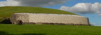
Older than Stonehenge and the great pyramids of Giza stands Newgrange, the heart of legends and mysteries stretching back five thousand years. Situated along the river Boyne near to numerous other such places like Knowth and Dowth, that very same river where Fionn Mac Cumhaill was said to have first found and tasted the salmon of knowledge, and the ... [more]


